SceneDraw 1.0
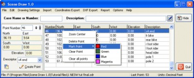
 SceneDraw is an investigative tool, for police and private investigators that need to survey and diagram scenes for criminal and civil litigation.
|
SceneDraw is an investigative tool, for police and private investigators that need to survey and diagram scenes for criminal and civil litigation.
Scene Draw is not a CAD program nor is it a drawing program, it is a Data Driven Diagram software program for your reconstruction purposes.
It is the complete data measurement collection software tool for Microsoft Windows 98 to XP. Whether you are collecting data points with a tape measure, an electronic distance meter or a total station, SceneDraw is just what the investigator has needed.
SceneDraw is not a CAD drawing software.
SceneDraw features
Limitations
tags![]() you can north east east south south west polar angle angle distance scenedraw coordinates various formats gathering all report gathering openoffice document can also export options
you can north east east south south west polar angle angle distance scenedraw coordinates various formats gathering all report gathering openoffice document can also export options

Download SceneDraw 1.0
Purchase: ![]() Buy SceneDraw 1.0
Buy SceneDraw 1.0
Authors software
 SceneDraw 1.0
AK Corp and Delicad
SceneDraw is an investigative tool, for police and private investigators that need to survey and diagram scenes for criminal and civil litigation.
Similar software
 SceneDraw 1.0
AK Corp and Delicad
SceneDraw is an investigative tool, for police and private investigators that need to survey and diagram scenes for criminal and civil litigation.
 Points Export for AutoCAD 1.0
Floating Point Solutions Private Limited
Points Export for AutoCAD is a plug-in for AutoCAD.
 Points Import for IntelliCAD 1.0
SYCODE
Points Import for IntelliCAD is a Point Text file import plug-in for IntelliCAD powered applications.
 Survey Import & Export 2005 3.0
CADD Productivity
Survey Import & Export works with AutoCAD (dwg) and coordinate data in formats such as txt, ascii, and csv.
 InnerSoft CAD for AutoCAD 2007 3.8
InnerSoft
InnerSoft CAD is a add-on component for AutoCAD that allows you to: Export to a Excel Sheet the values of Area/Length property or coordinates for various AutoCAD entities.
 Precision Image Digitizer 1.1
Michael Robinson
With Precision Image Digitizer you can trace and record the coordinates of your selected points in a JPG, GIF, or BMP.
 TopoLT 5.2
S.C. 3D Space S.R.L.
TopoLT is a very useful application for those who design topographical or cadastral plans in digital format.
 MyPlot Chart Editor 1.0
YPS software
MyPlot is the analogue of text editors in the area of plotting.
 RapidDXF 4.0
DeliCAD
RapidDXF is a program that will allow you to import topographic datas in your CAD system.
 JustCad 7.0
Jon Hoke
JustCad is configurate, to make cad drawing as simple as possible even for a beginer.
Other software in this category
 WinCal 4.9.0
TechSys Consultants Pty. Ltd
As we say, it is your personal photo calendar, Certificates and advertisements design and publishing tool.
 Color Wheel Pro 2.0
QSX Software Grou
Color Wheel Pro is the only tool that allows you to see color theory in action: you can create harmonious color schemes and preview them on real-world examples.
 Silver Pilot 1.12
Two Pilots
Silver Pilot is made for conversion negatives into positives within two easy steps: you just select a clear area in the margin of the film or clear film base and press the Start button.
 ReaWatermark 2.1
ReaSoft Development
ReaWatermark will apply your watermarks to multiple files to protect your copyright.
 Process Revolution 2002(SE)
Silicon Mindset, Inc.
Silicon Mindset's Process Revolution 2002(SE) is a multi purpose business application essential to the optimization of any organization.